mail_outline sales@mediastorehouse.com
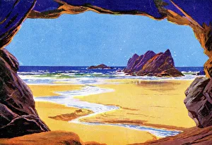
The Golden Sands of Wales, 1924This illustration of The Golden Sands of Wales comes from a souvenir booklet produced by the GWR to coincide with the 1924 British Empire Exhibition
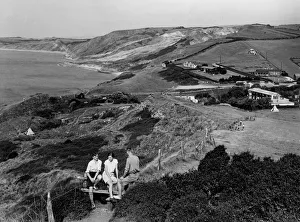
Osmington Mills, Dorset, c. 1930Three young walkers sit on a stile overlooking the coastal hamlet of Osmington Mills. The cliffs form part of the Jurassic Coast and are popular with fossil hunters
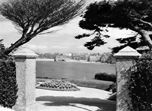
Newquay, Cornwall, 1933A GWR publicity view of the seaside town of Newquay in Cornwall, taken from the Towan Headland area in 1933. The image shows the cliffs and beaches of Newquay from between two gateway posts
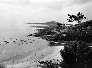
East Looe Beach, Cornwall, August 1936A GWR publicity view of East Looe Beach on the Cornish coast, August 1936. This image was taken from the cliff overlooking the beach
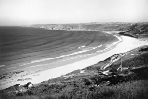
Kynance Cove, Cornwall, July 1924A GWR publicity view of the coast at Kynance Cove in Cornwall, July 1924. The stretch of sand seen here is Pentreath Beach
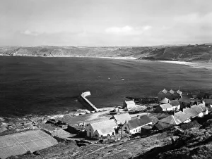
Sennen Cove near Lands End, Cornwall, c. 1950A GWR publicity view of Sennen Cove near Lands End in Cornwall, c.1950, showing the village in the foreground with the Porth Senan harbour wall stretching out into the dark water of the bay
Challaborough Cove, Devon, August 1928A GWR publicity view of Challaborough Cove near Bigbury-on-Sea in Devon, August 1928. Challisborough Beach is seen here on a quiet day in summer with a couple of small boats beached on the sand at
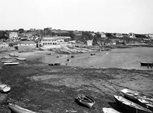
Challaborough Cove, near Bigbury-on-Sea, Devon, September 1935A GWR publicity view of Challaborough Cove in Devon, taken from the Bigbury-on-Sea direction in September 1935. Challisborough Beach is seen here on very quiet sunny day in late summer
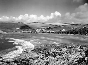
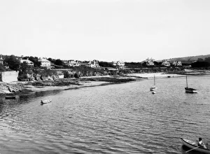
Burgh Island, Devon, September 1935A GWR publicity view of Burgh Island on the southern coast of Devon. Taken from Bigbury or Bantham Sands, opposite Bigbury-on-Sea in September 1935
Bigbury-on-Sea & Burgh Island, Devon, August 1928A GWR publicity view of Bigbury-on-Sea & Burgh Island on the southern coast of Devon, August 1928. Burgh Island is a small tidal island connected to the mainland at low tide via Bigbury Beach
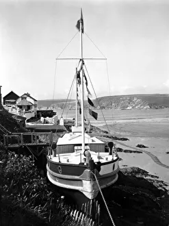
Burgh Island, Bigbury-on-Sea, Devon, September 1935A GWR publicity image taken from Burgh Island near Bigbury-on-Sea in Devon, September 1935, showing a beached small pleasure yacht
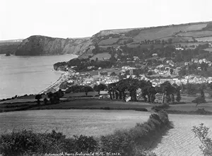
Sidmouth from Salcombe Hill, Devon, October 1925A GWR publicity view of Sidmouth taken from Salcombe Hill in Devon in October 1925. The view shows Sidmouth surrounded by fields and cliffs to the east and west
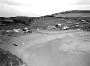
Dixcart Bay, Sark, 1925A GWR publicity view of Dixcart Bay on southern coast of Sark in the Channel Islands, taken in 1925. This image shows the sand and pebble beach at low tide
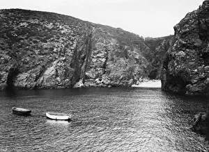
Havre Gosselin, Sark, 1925A GWR publicity view of Havre Gosselin on the western coast of Sark in the Channel Islands, taken in 1925. A number of small boats are using this natural harbour to moor up safely
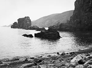
Les Autelets, Sark, 1925A GWR publicity view of Les Autelets on Sark in the Channel Islands, taken in 1925. These rocks have been painted and photographed for well over 100 years
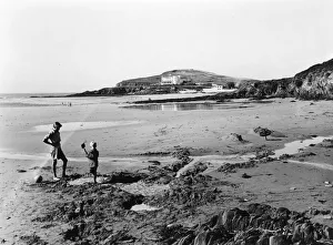
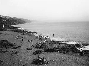
Porthleven Beach, Cornwall, July 1923A GWR Publicity view of Porthleven Beach, near Helston in Cornwall, July 1923. Holidaymakers are playing on the beach and in the sea. The rugged Cornish coastline stretches into the distance
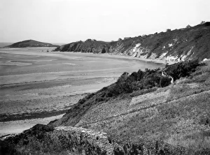
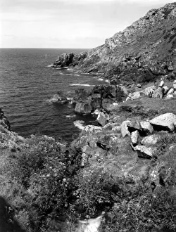
Zennor, Cornwall, August 1928A GWR Publicity view of Zennor Cove, near St. Ives, Cornwall in August 1928. The rugged Cornish coastline stretches into the distance
Sennen Cove, near Lands End, CornwallA GWR Publicity view of the Penwith Heritage Coastline at Sennen Cove, near Lands End, Cornwall in the early 20th century
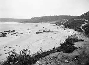
Sennen Cove and Whitesand Bay, CornwallA GWR Publicity view of Sennen Cove, near Lands End in Cornwall in the early 20th century. This picturesque Cornish village clings to the coastline while Sennen Beach is quiet in the sunshine
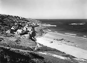
Sennen Cove, Cornwall, c. 1910A GWR Publicity view of Sennen Cove (Porth Senan), near Lands End, Cornwall, c.1910. The pale sand of Sennen Beach stretches into the distance as the coastline curves round to form a quiet Cornish
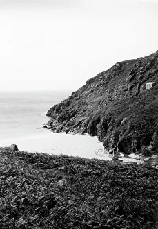
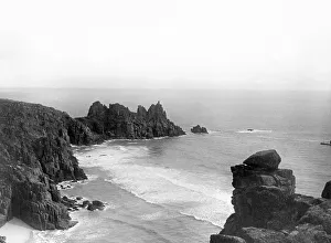
The Beach and Cliffs at Porthcurno, Cornwall, 1928A view of the beach and rocky coastline at Porthcurno on the southern tip of Cornwall, taken in August 1928
Porthcurno Beach and Rocks, Cornwall, 1928A view of the beach and rocky coastline at Porthcurno on the southern tip of Cornwall, taken in August 1928
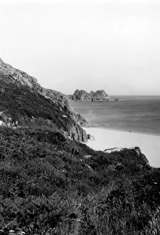
Treen Castle Rocks near Porthcurno, Cornwall, 1924A view of Logan's Rock otherwise known as Treen Castle Rocks near Porthcurno at the south western tip of Cornwall, taken in 1924
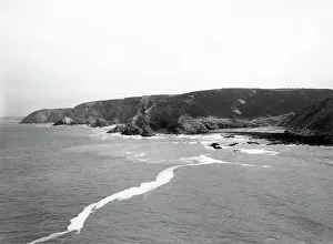
St Agnes, Cornwall, 1928A view of the coastline at St Agnes on the northern coast of Cornwall, taken in September 1928. Trevellas Cove can be seen on the right side of the image
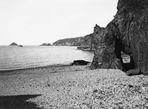
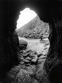
Porthgwarra Beach, CornwallA photograph of Porthgwarra Beach at the tip of Cornwall, taken in 1924. This view shows a man by a small boat on the beach through one of the coastal rock formations common at Porthgwarra Cove
Treveal Cove, St Ives, June 1946A GWR publicity of Treveal Cove at St Ives in Cornwall, taken in June 1946 to publicise rambling using the GWR network along the Cornish Riviera
Clodgy Point, St Ives, Cornwall, June 1946A GWR publicity view of Clodgy Point at St Ives in Cornwall, taken in June 1946 to publicise rambling using the GWR network along the Cornish Riviera
Clodgy Point, St Ives, June 1946A GWR publicity view of Clodgy Point at St Ives in Cornwall, taken in June 1946 to publicise rambling using the GWR network along the Cornish Riviera
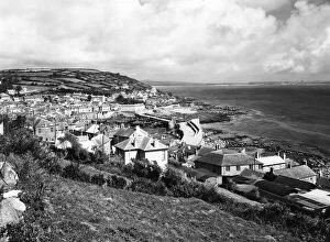
Mousehole, Cornwall, c. 1938A GWR publicity view of the fishing village, Mousehole in Cornwall, c.1938, showing the harbour in the centre of the image
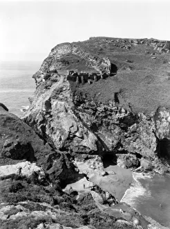
Tintagel Castle Beach, August 1927A GWR publicity view of the ruins of Tintagel Castle on the rugged northern coast of Cornwall. This image looks down into the valley and the beach between the medieval castle and the mainland
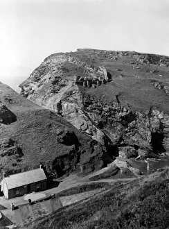
Tintagel Castle, August 1927A GWR publicity view of the ruins of Tintagel Castle on the rugged northern coast of Cornwall. This image looks across the valley between the medieval castle and the mainland
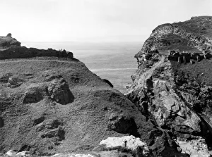
Tintagel Castle, view across the creek, August 1927A GWR publicity view of the ruins of Tintagel Castle on the rugged northern coast of Cornwall. This image looks across the creek between the medieval castle and the mainland
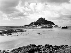
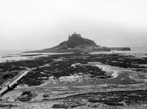
St Michaels Mount at Low Tide, August 1935A GWR publicity image of the Cornish landmark St Michaels Mount at low tide, August 1935. Some people are walking along the causeway between the castle and Marazion Beach
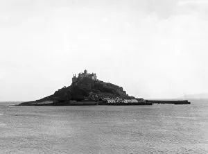
St Michaels Mount at High Tide, August 1928A GWR publicity image of the Cornish landmark St Michaels Mount at high tide, August 1928. The causeway linking Marazion to the castle is nowhere to be seen
St Michaels Mount at Low Tide, August 1928A GWR publicity image of the Cornish landmark St Michaels Mount at low tide, August 1928. A ribbon of people are walking along the causeway between the castle and Marazion
St Mawes from the Castle, Cornwall, August 1928A GWR publicity view of the coastal village of St Mawes in Cornwall, taken in August 1928 from St Mawes Castle
St Mawes Harbour, Cornwall, August 1928A GWR publicity view of the village of St Mawes in Cornwall in August 1928, showing a number of small boats moored up in the harbour
St Mawes, Cornwall, August 1928A GWR publicity view of Summers Beach at the village of St Mawes in Cornwall in August 1928. The image shows several small boats moored up in the harbour
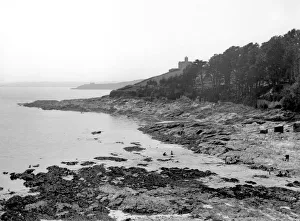
St Mawes Castle, Cornwall, 1924A GWR publicity view of a cove near the village of St Mawes in Cornwall, 1924. Henry VIIIs artillery fort St Mawes Castle can be seen behind a line of trees
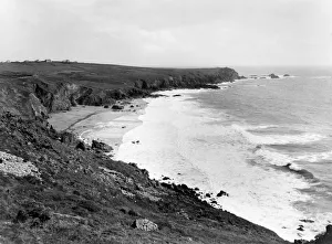
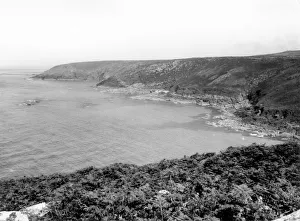
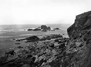
The Coastline Between Lizard and Kynance Cove, Cornwall, July 1924A GWR publicity view of the coast between Lizard and Kynance Cove in Cornwall, July 1924, showing the dramatic cliffs and rolling waves crashing onto rocks
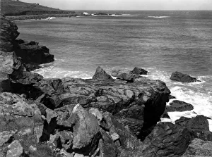
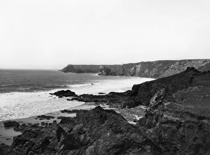
Between Lizard and Kynance Cove, Cornwall, July 1923A GWR publicity view of the coastline between Lizard & Kynance Cove in Cornwall, July 1923, showing the dramatic cliffs, rock formations and crashing waves
The Coast Between Lizard & Kynance Cove, Cornwall, July 1923A GWR publicity view of the coastline between Lizard & Kynance Cove in Cornwall, July 1923, showing the dramatic cliffs and crashing waves
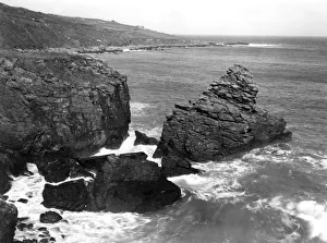
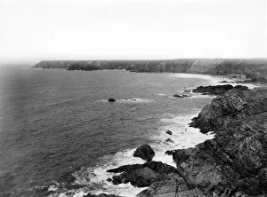
Lizard Point, Cornwall, July 1923A GWR publicity view of Lizard Point in Cornwall, July 1923, showing the most southerly part of the UK and the old lifeboat station and its slipway
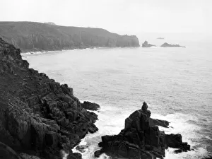
Lands End & The First and Last House, Cornwall, c. 1950A GWR publicity view of Lands End in Cornwall, taken from the south side near the First and Last House at the top of the cliff, c.1950
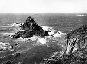
Lands End and Longships Lighthouse, Cornwall, c. 1950A GWR publicity view of Lands End and Longships Lighthouse, Cornwall. Taken on a sunny day c.1950 the lighthouse is clearly visible beyond the rugged rocks below the cliffs
Lands End, Cornwall, c. 1950A GWR publicity view of the southern side of Lands End in Cornwall, c.1950, showing the First and Last House and the rugged rocks below
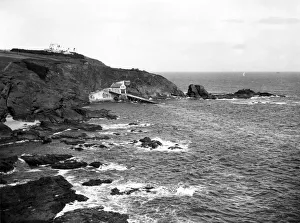
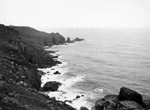
Lands End and Longships Lighthouse, Cornwall, c. 1928A GWR publicity view of the northern side of Lands End, Cornwall, c.1928, showing Longships Lighthouse in the distance
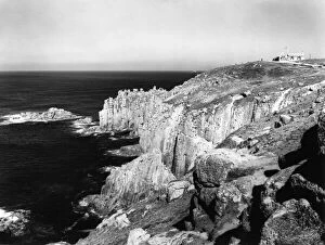
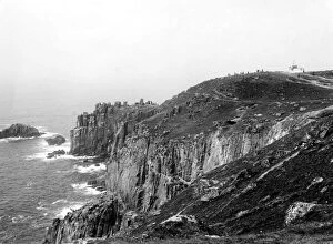
Lands End, Cornwall, c. 1928A GWR publicity view of the north side of Lands End, Cornwall, c.1928, showing the rugged coastal cliffs